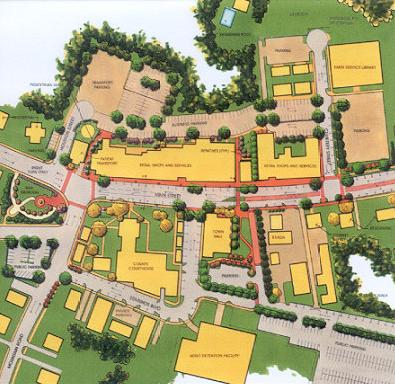
The following illustration provides an overall master plan of the study area. The study area for this project was divided into two zones, one the "Core Downtown Area" from Cemetery Street north through Mountain Road, and the other the "Approach Area" from Toots Creek north to Cemetery Street. Separate but related recommendations were developed for each of these zones. Pictures illustrating the deteriorated existing conditions are also provided.
Main Street Traffic and Roadway Design
U.S. Highway 501 is a main truck route through the Town. Along with the cars bringing people to do business at the courts and the regional jail, this highway creates a dangerous pedestrian condition throughout the business area. There are no marked pedestrian crosswalks and accidents include one fatality in recent years. The paved roadway is wider than necessary for the traffic, leading to a tendency for higher travel speeds than desired as well as to difficulty in pedestrian crossings. The plan recommends a series of "traffic calming" measures that will address both of these issues while providing needed tree and greenspace planting areas. Typical roadway sections were developed for each zone of the roadway.
 Core Area.
The core area extends from Cemetery Street north past the Mountain Road intersection. The overall recommendations for Main Street design within the core area include:
- Relocation of overhead utilities from Main Street. Most of these will be relocated and consolidated to new poles along Houston Street. Overhead utilities were found to be one of the biggest eyesores along the core area with its narrow pedestrian walk, and the poles, often off vertical, are a hazard to pedestrian movement.
- Retention of parallel parking on both sides of the street with the parking zone delineated by chokers. Parking is essential to downtown businesses.
- Provision of dedicated left turn lanes at Mountain Road and Edmunds Boulevard.
- Provision of new curbs and sidewalks along both sides of the street. Sidewalks will be patterned concrete in a brick color to coordinate with existing materials. The new curbs and grading will require resurfacing of the roadway paving to establish positive drainage away from the building faces. Sidewalks are in an extremely deteriorated and dangerous condition, with grade and alignment changes and large holes where poles have been removed. Due to various alterations in drainage and bad surface elevations, curbs vary from nonexistent to several inches high. The replacement of curbs necessitates resurfacing of the roadway and drainage improvements.
- Development of new drainage piping within the right-of-way to improve walkway drainage and prevent water flowing towards building entrances. Major drainage pipes for the roadway extend under buildings on the east side of Main Street. These will be abandoned and replaced by pipes running along the street with a new outfall to ravines east of Houston. The new roadway drainage will allow for the design of a more consistent curb height and better, safer definition of the pedestrian walk area.
- Addition of pedestrian scale lighting on both sides of the street to enhance safety and appearance.
- Addition of colored pressed asphalt pedestrian crosswalks at Mountain Road, the Town Hall Plaza, and at Cemetery Road to clearly define key pedestrian crossings.
